
Harmonized Landsat and Sentinel-2 (HLS)
The Harmonized Landsat and Sentinel-2 (HLS) project is an extension of research conducted at NASA GSFC (Goddard Space Flight Center) in Greenbelt, MD, and produced at NASA MSFC (Marshall Space Flight Center), that takes input data from the joint NASA/USGS Landsat 8 and Landsat 9 and the ESA (European Space Agency) Sentinel-2A, Sentinel-2B, and Sentinel-2C satellites to generate a harmonized, analysis-ready surface reflectance data product with observations less than 1.4 days globally on average and less than 1.9 days in the tropics. The temporal coverage of the HLS dataset extends from the first Landsat 8 acquisitions in 2013 and the first Sentinel-2 acquisitions in 2015 to the present.
The HLS project is a major outcome of the Satellite Needs Working Group (SNWG) assessment in 2016. In that assessment, federal agencies and end users identified a need for more frequent Landsat-like observations to track short-term changes in vegetation and other land components to support agricultural monitoring and land cover classification at moderate to high resolution in both the visible and thermal components of the electromagnetic spectrum. Spectral similarities between the Landsat 8 Operational Land Imager (OLI), the Landsat 9 OLI-2, and the Sentinel-2 Multispectral Imager (MSI) enables the harmonization of data from these sensors to generate higher-frequency imagery products for land surface monitoring and applications.
Previous versions of HLS data products produced by the HLS Science Group at Goddard had limited spatial coverage — only covering North America and other select global locations. The current version (v2.0) of the HLS algorithm is a cloud-based software stack that expands the spatial coverage to include all land masses globally, except for Antarctica.
NASA’s Harmonized Landsat and Sentinel-2 (HLS) project is a groundbreaking initiative that combines data from Landsats 8 & 9 with the European Space Agency’s Sentinel-2A & 2B satellites, circa 2024, and currently includes Sentinel-2 C. Let’s take a look at how HLS data is revolutionizing Earth observation, from aiding search and rescue operations in the aftermath of hurricanes to helping farmers optimize crop yields. Join us on a journey through the cutting-edge world of remote sensing and explore the future of monitoring our planet’s health with HLS.
Two primary surface reflectance data products are generated as part of the HLS project: the L30 data product generated with Landsat data, and the S30 product generated with Sentinel-2 data. A Vegetation Indices products suite (HLS-VI), derived from the L30 and S30 products, was introduced in February 2025, and HLS low-latency (HLS-LL) products are anticipated to be available in early 2027. These data products can be accessed via Earthdata, NASA’s Land Processes Distributed Active Archive Center (LP DAAC), and other platforms.
Improving Land Monitoring Capabilities
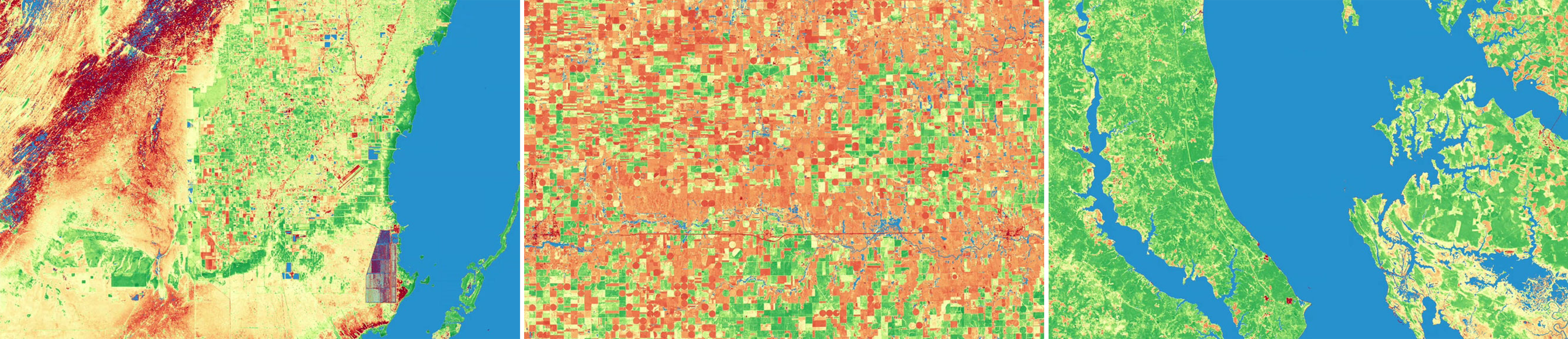
A one-year time series showing agriculture land use intensity around the Salton Sea, California, from October 12, 2024 through October 16, 2025.
Credit: NASA / Ross Walter
HLS data products greatly improve current publicly-available remote sensing land monitoring capabilities, particularly in terms of the frequency of land surface observations through time. The harmonization of HLS ensures that the Landsat 8 and Landsat 9 collection (30-meter spatial resolution with a 16-day repeat period) and the Sentinel-2A/B/C collection (10 to 20-meter spatial resolution with a five-day repeat period) can be used as if they were a single collection. Through HLS, land surface observations can be acquired at an unprecedented 30-meter spatial resolution at a temporal frequency of global average of <1.4 days.
The frequent revisit times of HLS supports monitoring of dynamic phenomena—including wildfire recovery, crop cycles, and storm damage—more effectively than Landsat or Sentinel-2 alone. Data from the Sentinel-2C mission (launched in 2024) is now active and incorporated into HLS v2.0 data products, further improving revisit times and land monitoring capabilities.

The temporal frequency of HLS revisit times has improved with the launch of each satellite. This virtual constellation harmonization achieved a temporal revisit from 1.6 days in 2022 with four satellites and 1.4 days in 2025 with five satellites. Credit: HLS Science Group.